Kheerganga Trek
Everything You Need to Know
Trail routes, best seasons, packing list, how to reach, altitude guide, and safety tips — your complete Kheerganga trekking reference.
Max Altitude
2,960m
9,711 ft
Trek Distance
11–14 km
One way
Trek Duration
4–5 hrs
ascent
Difficulty
Easy–Moderate
beginner friendly
Temperature
5–20°C
at summit
Best Season
May–Nov
open year-round
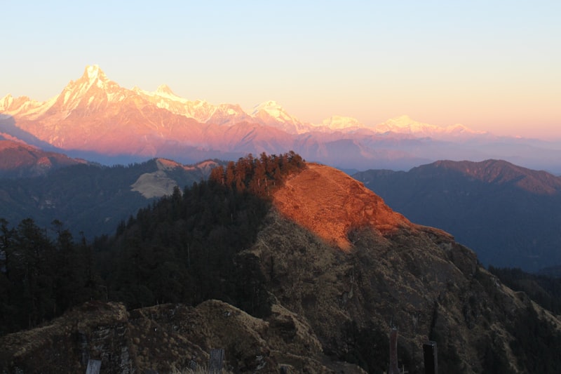
Kheerganga — The Himalayan Hot Spring Trek
Nestled at 2,960 metres in the Parvati Valley of Himachal Pradesh, Kheerganga is one of India’s most beloved short treks. The name means “river of milk” — a reference to the milky-white streams that flow from the natural hot springs at the summit meadow.
The trek winds through dense oak and deodar forests, past the sacred Rudra Nag waterfall, through the traditional mountain village of Nakthan, and culminates at the vast open meadow where Shiva is said to have meditated for 3,000 years.
At the top, natural geothermal hot spring pools — separate for men and women — offer a remarkable and deeply relaxing experience after the climb. On clear nights, the sky above Kheerganga is alive with stars, making it one of the best stargazing spots in Himachal.
Trek Highlight
Natural Hot Springs at 2,960m
Geothermal pools open year-round
How to Reach Kheerganga
Barshaini village at the base of the trek is the nearest motorable road point. Here are all the ways to get there from major cities.
From Delhi (Bus)
~10–12 hours
Take an overnight Volvo/HRTC bus from Kashmere Gate ISBT or Majnu Ka Tilla
Tip: Volvo semi-sleepers are the most comfortable option.
Book tickets at least 2–3 days in advance via RedBus or HRTC website.
From Delhi (Train + Cab)
~8–10 hours
Tip: The Chandigarh to Kasol road passes through Mandi and Kullu — a stunning mountain drive.
From Delhi (Fly)
~45 min flight + 2–3 hr drive
Tip: Bhuntar airport is small and flights are weather-dependent. Book refundable tickets when possible.
By Private Car / Self-Drive
~10–12 hrs from Delhi
Tip: Park your vehicle at Barshaini parking (paid). The road from Kasol to Barshaini is narrow — drive carefully.
Distance Reference
From Delhi
~520 km
to Barshaini
From Chandigarh
~315 km
to Barshaini
From Manali
~100 km
to Barshaini
From Bhuntar
~35 km
to Barshaini
Safety & Health Tips
Kheerganga is a beginner-friendly trek, but the mountains demand respect. Read these essential safety guidelines before you go.
Altitude Awareness
- Kheerganga sits at 2,960m — altitude sickness is unlikely but possible for very low-altitude residents.
- Symptoms: headache, nausea, dizziness. Descend immediately if severe symptoms occur.
- Stay well-hydrated throughout the trek. Drink 3–4 liters of water per day.
- Avoid alcohol on Day 1 at altitude. It accelerates dehydration.
Trail Safety
- Never trek alone. Always go with a guide or in a group.
- Inform someone at base camp about your trek plan and expected return time.
- Stay on the marked trail. Off-trail exploration risks landslides and getting lost.
- Do not attempt the trek in heavy rain or post-rainfall conditions without guide assessment.
Water & Hydration
- Carry at least 2 liters of water from Barshaini. Refill at Nakthan village or at tea stalls.
- Do not drink directly from streams without purification tablets or a filter.
- Add electrolyte ORS sachets to water — this helps significantly with fatigue.
Weather & Environment
- Mountain weather changes rapidly. Always carry a rain jacket even in summer.
- Afternoons can bring sudden cloud cover and rainfall from June to September.
- Lightning is a real risk on exposed ridges. Descend below tree line if a storm approaches.
- Temperatures at Kheerganga drop to 5–8°C at night even in May/October.
Emergency Contacts
Mountain Rescue: 1800-180-1114 Kasol Police: 01902-232-001 Our 24/7 Support: +91 98765 43210
Save these contacts before you begin the trek. Mobile coverage is limited above Nakthan village — BSNL provides the best signal.
Ready to Trek Kheerganga?
Everything is sorted — guide, permits, camps, and meals. Browse our packages and book your dates.